Transcript from the podcast “Speak Out Loud: Stories of Strength from the Southern Downs”
SEASON 2: EPISODE 7
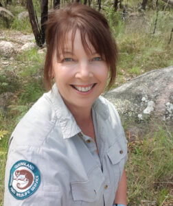
GUEST: Jolene Nelson, Acting Senior Ranger – Visitor Management
South West Region, Queensland Parks and Wildlife Service & Partnerships
Department of Environment and Science
PUBLISHED: 14th March 2022
[00:00:00] Jolene: I guess what any National Park, or any protected area brings to people is that chance to reboot and reset and disconnect from everything, you know, the busy life that you might have come from. You’ve just got the sights and sounds of nature to enjoy. And it’s just a very simple and nice, easy way to just connect with yourself as well as with nature.
[00:00:34] Kathryn: Today’s episode is with Jolene Nelson, who is the Visitor Management Ranger for the South West Region. Jo chats with me about the National Parks in the region, the activities that are on offer, and she shares with us the recovery journey that she’s seen following the bush fires, particularly at Girraween National Park where she’s worked for over 20 years. The region has some incredible green spaces. And I really hope that this episode inspires you to get out there, to get active and to connect with nature.
Welcome to the podcast Jo. Can you tell us what’s your connection with the Southern Downs Region?
[00:01:13] Jolene: Well, I have pretty much been connected with this region for half of my life. I moved here when I was 28. I’ve worked out at the National Park at Girraween for the last 25 years. So yeah, I’ve kind of grown up here. I’ve had a family here. I love this community. I certainly found my niche. There’s so many different flavours in the region, as far as the environment and the culture and arts and food and wine and so on. I really do love this area. It’s something that I don’t hold back sharing with people.
[00:01:46] Kathryn: So you mentioned Girraween, can you tell us a little bit about the National Parks that are in the Southern Downs Region?
[00:01:52] Jolene: Yeah. So I probably talk about Girraween a lot because it’s kind of my favourite. But we are very lucky in this region. We do have a few different National Parks. We’ve got Girraween and Sundown National Parks on the Queensland side of the border. And then just a little bit across the border out of our region, of course is, Bald Rock and Boonoo Boonoo National Parks. But then we also have state forests as well. So where I live, I actually back onto Broadwater State Forest. And then just a bit further north is Passchendaele State Forest. So lots of protected areas, lots of places to play, lots of recreational opportunities, camping, walking, hiking overnight, mountain biking, a lot of bird watching, nature, just places to reset and enjoy and experience nature and in beautiful environments. And our climate is perfect, all year round, really, you can go walking, it’s not too hot. But there’s lots of places to swim if you do. So. So yeah, that’s what we’ve got around our region. We’re very lucky.
[00:02:48] Kathryn: In 2019 and 2020, there were some bush fires that came through the region. And that happened after several years of drought. And more recently, the region has had some flooding and we’ve seen lots of regrowth since then, but in general, how have all these different weather and climatic events impacted the National Parks in the region?
[00:03:13] Jolene: Yeah, look, I guess it’s the nature of our business. We do work in a natural environment and it’s shaped by, you know, what’s going on in the big picture. So the weather will definitely shape what’s going on down on the ground. In my time, like I’ve been there for many wildfires. We had a big one back in 2002, another one in 2005, another one in 2015, but the 2019 one was certainly odd being February. It’s not generally when we have our wildfires and it was kind of cold, like we were actually rugged up on the fire line. But that unfortunately was because we just had so much fuel because of the drought that, you know, leading up to that wildfire. And then Broadwater State Forest, was the big fire that impacted on Stanthorpe more so. That was also pretty crazy. Unfortunately it was, it occurred or started on an extreme fire danger day. Actually it was catastrophic, I should say. Yeah, it was, it was just horrible when it happened and, we knew that at some stage there would be a fire in Broadwater, but we just didn’t know to that extreme and threatening town like it did. But as far as these environments, yes, we do have these extremities. We’ve got the fires and I’ve also experienced a few floods in the region, 2011 and then again, last year, and even this year we’ve had the little sort of flash floods. And then drought. To experience the two year, 2018 to 20 drought, you know, that was the biggest for our region. Like they’re hard, you know, you fall in love with these environments and then I guess it’s like seeing a friend stressed and, and not at their best, you kind of, um, it touches your heart. You know, I would go out to Girraween to work and I would see ridges of trees dying. And yeah, it was, it was heartbreaking. And then I’d come home and I’d see my own backyard, you know, stressed. You would see populations reducing. It was really hard times, but I guess the recovery of these things is amazing, you know, and that’s nature is that you hope in the long run, yes at the time things might look terrible, but in the long run, you hope that they’re going to recover to some state where, you know, you can still go out and not see the ridges of trees dying and so on.
[00:05:29] Kathryn: You mentioned those fires that you’ve witnessed or, you know, are aware of in the last 10, 15, 20 years as well. So I’m imagining that you’ve seen recovery taking place from each of those over the longer term?
[00:05:46] Jolene: Yes, definitely. I mean, I guess after a fire, you do start to see the epicormic shoots and the regrowth starting to happen. It was a bit of a slower recovery process because of the drought. We didn’t have the follow-up rain that would generally help recover the bush. But eventually it has got there. I’ve had a few days where, I’ve kind of had a little cry, but of joy. And one of those was actually, it was exactly this time two years ago. I was at, down The Junction and finally seeing the creeks flowing. And it was like, this rain is pumping life into Girraween again. So, you feel really warm and fuzzy and hopeful that things are going to come back. And I can tell you that two years later, the bush is looking definitely healthier. We’re seeing species recover. I think we just had one of our best wildflower seasons. We’re seeing orchids that we hadn’t seen for a couple of years you know, come back out. We’ve got naturalists doing field studies, finding quolls. We’ve seen wombats on cameras. The bird life, the reptiles, everything seems to be coming back. So that’s, yeah, a really good sign of, um, better times ahead. Hopefully.
[00:06:54] Kathryn: That must be really exciting to see those changes.
[00:06:57] Jolene: Oh it is for me personally, um, yeah, beautiful. Like I go for a walk in the bush now and I’m not so kind of worried and stressed out. I just am now just back to enjoying it and getting back to discovering things about why I love being out where I am.
[00:07:12] Kathryn: Preparation for natural disasters like fires and, and drought and the floods as well can be really valuable, not just for survival, you know, surviving that particular disaster, but also for the longer term recovery for the land and the people. How do you prepare and plan for bush fires in a landscape such as Girraween?
[00:07:37] Jolene: Yeah, look a huge component of our jobs as Rangers is we’re fire managers. So it’s not just about being there as a firefighter. It’s about the years and months ahead, where you’re actually putting your thoughts and your learnings and your training into coming up with fire strategies. Now we develop fire strategies for our National Parks up to 10 years. Um, and then we’ll you know, narrow that down. It might be a year burn plan that you will come up with about where the best places need to be looked at at that time. We work with other agencies as well, so that we can at a larger level, look at our landscape and see what we need to do, to protect our communities as well as our environment. Through the year, like winter there’s a lot of work that goes into the preparation for the coming fire season. So that’s anything from slashing your fire trails to making sure your neighbours’ contacts are up to date. Your roads are maintained, so they’re ready and doing those prescribed burns, working with our First Nations People. Cultural burning and prescribed burning can be a little bit different. So combining the two definitely is more productive, uh, more effective we’ve found. And then I guess you go into the warmer seasons and it’s about being prepared and ready and trained and having resources and just waiting for those horrible extreme fire danger days and making sure your work plan is revolving around what’s going on out in the environment and you’re ready. And yeah just once you get those calls, just getting onto fires wildfires as soon as we can. So yeah, there’s, there’s a lot that we can do and that we do do, but there’s also, you know, nature that sort of will take its toll and determine how our days turn out.
[00:09:22] Kathryn: Natural environments like our National Parks are really valuable spaces for lots of different reasons. And from a mental health perspective, they give us the space to get active and have social gatherings and get connected with the natural world. What are some of the activities that people can do when they visit the National Parks such as Girraween and Sundown?
[00:09:46] Jolene: We’ve got many different types of recreational opportunities available in the different areas. So Girraween, it’s obviously very busy. But that’s because we’ve got the walking tracks that will cater for those numbers. We’ve got the small half-hour walks through to, you know, six hour walks if you’re prepared and want to, um, there’s the overnight hikes. We’ve got remote camp sites and we’ve got our camping areas as well. So, they’re kind of the main things that goes on. Lots of walking and camping. But then you’ve got rock climbing, you’ve got mountain biking, there’s orienteering. There’s a lot of birdwatching people. Naturalists love Girraween because it’s kinda like a little biological island. We’ve got a lot of species that you won’t find further north, south, east, and west. So it’ll bring a lot of your bird watchers, people that love reptiles, spotlighting at night for possums and gliders. You know, many go looking for wombats, but you gotta be lucky to spot one of those. But then you have Sundown, which is only an hour or so away from Girraween and it’s way more remote. So you’ve gotta be really prepared there. You can do remote walks and hikes. There is the Severn River, so you can go paddling, have a swim, you can even fish. And four wheel driving of course, because of its remoteness and ruggedness. So yeah, different opportunities, but I guess what any National Park, or any protected area brings to people is that chance to reboot and reset and disconnect from everything, you know, the busy life that you might have come from. You’ve just got the sights and sounds of nature to enjoy. And it’s just a very simple and nice, easy way to just connect with yourself as well as with nature. And yeah, I, I personally get a lot of calmness out of being in the bush, whether it is a ride or a walk or a climb or a swim, just to focus on yourself and just what’s important in life, I guess, you know, about looking after yourself.
[00:11:43] Kathryn: If anyone’s listening is interested in coming along to one of the National Parks and doing any of those activities, camping, for example, or bushwalking, where can they go for more information or to make a booking?
[00:11:57] Jolene: You can either just Google Girraween, and it’ll come up as the number one website, but for any of our National Parks, if you just go to the Department of Environment and Science and look for camping or booking online, you’ll just follow the links and you’ll find it.
[00:12:10] Kathryn: Jo, is there anything else that you’d like to share about the National Parks?
[00:12:15] Jolene: Girraween in particular again, the jewel of the crown, for me, it’s one of our iconic parks in Queensland. It’s actually going through a facelift at the moment. So yes. Had some hard days, but it’s having some funds injected into it to up grade our camping areas. So we’re closing Castle Rock, and that’ll be the first one to receive the facelift. And by the end of June, we hope to have three camping areas in Girraween that will cater better for the groups that we have coming. Big things happening for us, and I guess, with COVID we’ve seen that a lot of people have the need to go to these beautiful open places and be with nature. And, so I’m hoping that this is going to be a lovely way that we can get past this pandemic.
[00:13:01] Kathryn: Lots of opportunities for people to get out there and get active and nurture themselves.
[00:13:06] Jolene: Exactly, exactly. And yeah. Leave those gadgets at home. Bring some marshmallows, sit around the campfire with the kids and then just enjoy nature.
[00:13:16] Kathryn: That sounds beautiful. Thank you, Jo.
Thanks for listening to the Speak Out Loud Stories of Strength podcast with me, Kathryn Walton. I hope this episode inspires you to get involved and to get connected with your community. You can find the transcript and any links mentioned in this episode, in the show notes and please share the podcast with your friends. We acknowledge and pay respect to the past, present and future Traditional Custodians and Elders of this nation and the continuation of cultural, spiritual, and educational practices of Aboriginal and Torres Strait Islander peoples. Series Two of this podcast has been jointly funded under the Commonwealth and State Disaster Recovery Funding Arrangements 2018.
